I have been asked about Big Bend National Park rainfall many times. Although it is a desert, the higher elevations can be surprisingly lush during years of ample rainfall. Subterranean aquifers are recharged and the desert springs react with renewed flow. This is important to the wildlife of the region and useful in planning for backpackers. When trying to correlate short term trends, one has to be careful and the Big Bend National Park Rainfall data I’m presenting is no exception.
UPDATE:
I promised I’d update the original post from Aug 26, 2016. It turned out to be an exceptional year for rainfall in the Chisos Mountains. The final recorded rainfall total was 25.43″ as of December 31st, 2016. Referring to the plots below, you will note annual rainfall in excess of 25″ is rare. It has occurred in only 8 years between 1940 and 2015.
As usual, January-March has been dry. As of April 01, 2017, the Chisos Basin has received less that 1″ of rainfall. This is typical for this time of year. It will be of interest to see what the wet season brings this year.

Research
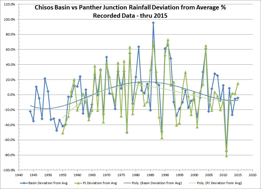
With a little research, I have collected some recorded weather station data for Big Bend National Park Rainfall. The data comes from two locations. The first location is the Chisos Basin with an elevation of ~5400′. The second location is Panther Junction with an elevation of ~3750′ As you will see in the data, the rainfall amounts are vastly different in the two locations even though they are only separated by a distance of about 7 miles, as the crow flies. In the desert, elevation is everything.
Over many years and many visits, I decided to match some observed data with recorded data. These observations are empirical and by no means extensive. They are short term and may be completely erroneous! Regardless, not believing in coincidence, some of my observations of desert springs and surface water seem to be valid.
Below are some photos taken following periods of above average rainfall in the Chisos Mountains. In addition, charts of historical Big Bend National Park Rainfall data that I mined from the Western Regional Climate Center, Take a look at the data and draw your own conclusions. This is very unscientific, but the photos don’t lie. I use the accumulation of 20″ in the Chisos Basin as a signal that ephemeral desert springs may be active. This number is not used in isolation. Previous years are factored in. Serious drought years like 1989 and 2011 can impact the following year(s) even if the 20″ mark is met. The only way to know for sure is to hike out and check.
The Data


The summer of 2016 is turning out to be an above average year in the Chisos Basin. I will try to add additional observations thru the fall and thru early spring 2017 and see if there is additional confirmation. I will update this post when I get the additional observations. Stay tuned…
Great pics
Thanks! Stay tuned, I’m going to post some more soon.