Hiking Big Bend National Park can be tame or as challenging as one could ask for. This report details a week of both with the focus being on off-trail experiences.
The Plan
Normally I would avoid Hiking Big Bend National Park during Spring Break. This year my daughter wanted to do something and Big Bend was a likely choice. Since she couldn’t get there til the March 12th, I agreed to go early to avoid the rush (great sacrifice 🙄 ) to snag a campsite in the Basin Campground. I left Houston on the March 7th and drove as far as Seminole Canyon State Park on the first day.
Seminole Canyon
The Seminole Canyon campground was surprisingly full with mostly RV seniors. After spending the night, I took advantage of the hot showers and got an early morning start for the rest of the drive. Pretty uneventful, but Amistad reservoir levels are up to near normal and I spotted a bobcat near Sanderson and a few pronghorns near Marathon.
Day 1 Hiking
I arrived early at a mostly full campground, but managed to get a decent site (#14). After unloading and setting up my camp for the next 8 nights, I wanted to get a short hike in this day. My choice was Rough Spring. It was close, not long and I wanted to see if the spring was flowing. I had visited Rough Spring once before while Hiking Big Bend National Park in the month of February and there was good flow even during that dry time of year. It was time to find if this would be the case again.
The Hike
I parked at the Basin pullout at the bottom of the Basin Road, shouldered my packed with water, a few snacks and my trusty Nikon. Under partly sunny skies and mild temperatures, I struck out to the southwest over the low hills near the pullout. After about 3/4 of a mile of brushy cross country hiking, I dropped into the wash that would lead me to another that was coming from the spring. The first wash has a slickrock section and I was pleased to see the tinaja in that section was holding some water.

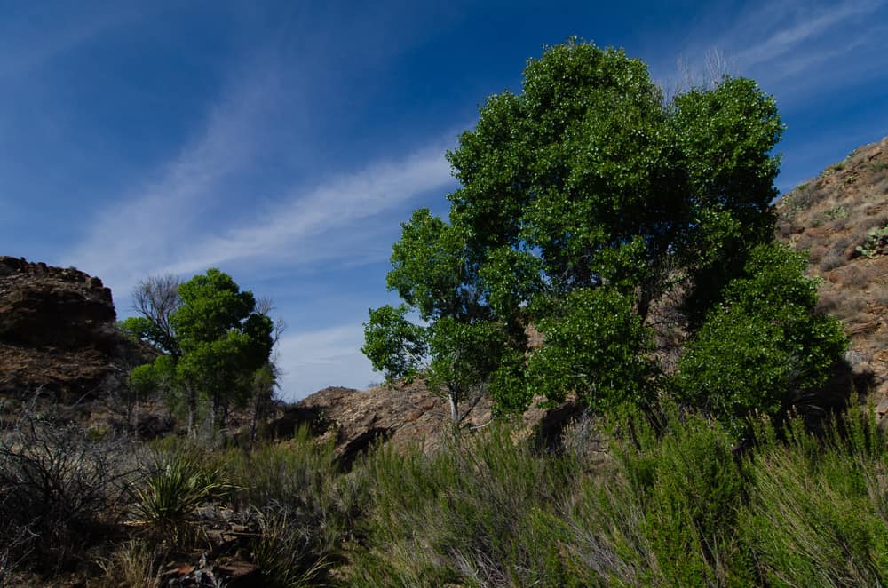
I worked my way downstream from the tinaja to the intersection with the Rough Spring wash and turned due south and followed it the the spring. As I got closer I could see the bright green of the cottonwoods ahead and was hopeful there would be some water too.
The Spring
Sure enough as I closed in on the spring location, it became clear that it was indeed flowing. Numerous tracks surrounded the gravel around the spring. Mostly javelina and deer tracks. I didn’t see any kitty or bear tracks.

Water was clear, cold, and abundant, with a good flow along a 75 yard stretch below the spring. Flowers were in bloom and the cottonwoods provided nice shade for a rest and a snack. The desert provides pleasant surprises when hiking Big Bend National Park.


I lazed in the shade of the healthy cottonwoods for a while and thought about my plans for the next few days until my daughter showed up. I had this nagging desire to explore the area around Ward Spring after being thwarted there once before when trying to reach Bell Spring, Patty Spring, and Patch Nose Seep. Not enjoying that defeat, I was ready to put that on the agenda for the next day of Hiking Big Bend National Park
While only two data points are not statistically significant, both times I have been to Rough Spring have been in the drier season. I conclude that the spring may be pretty reliable.
Day 1 was short but sweet. Logged 3.6 miles with about 1200′ total elevation change. Hiking Big Bend National Park is best as a multi day experience, so read on for Day 2.
Day 2 Hiking
Day 2 started with a mild, partly cloudy morning. I had a quick breakfast and drove to the Ward Spring Trailhead. The traffic on the Basin road was crazy and the Lost Mine trail parking was overflowing. The park had even set up a shuttle from the Basin Amphitheater parking area to the Lost Mine Trailhead. It was running every 45 minutes until about 3 PM and the last return from the LMT was about 5 PM. So many people…….There were no cars at the Ward Spring parking area, but Sam Nail Ranch parking area was also overflowing.
The Hike
I hit the Ward Spring trail for about 0.4 miles and then went cross country to the southeast towards Bell Spring. After about another 0.8 miles, the wash quickly closed up as I approached Bell Spring. I just started to noticed a bit of damp gravel. The wash turned and closed up against a small but very slickrock pouroff. Water was sheeting over the pouroff with a small flow but further progress at this point was not possible. The sheer walls, while not too high, were unclimbable.


Patty Spring
At this point, I needed to make a choice of whether to backtrack and exit the wash on the North or South side. If I exited South I might be able to get to Patch Nose Seep. The North exit would put me on route to Patty Spring. After studying the topo and visually surveying my options, I chose the North side to Patty Spring.
Nothing is flat when Hiking Big Bend national Park, so I bushwhacked above the wash to a point just above the Bell Spring dead end. The hike continued high on the ridge until I could drop back down into the wash below Patty Spring.

After a lot of zigging and zagging and crossing a solid rock slope, I was able to drop back into the wash. Pushing through some desert willow, (good sign) I turned a corner in the wash, and ran into a wildlife monitoring camera strapped and cabled to a rock.
UPDATE: I e-mailed the Park Biologist. He informed me the cameras are operated by Sul Ross State University, in cooperation with NPS. He agreed to share photos with me when the cameras were retrieved.


I worked my way about another 50 yards up the wash to another dead end. Here I found a small seep erupting at the base of the dike complex that Ward Spring erupts from. There was very little water.

The dike loomed high overhead and was the same dike that crosses at Ward Spring. I considered trying to cross over it and follow back to Ward, but It looked impassable from my viewpoint and skills.


At this point I decided to try Patch Nose Spring on a different day and backtracked to the wash below Bell Spring. I passed a Mexican Buckeye in bloom that was attracting hundreds of bees. Hiking back to the truck I didn’t encounter any other hikers. I made my way back to the Basin for a quiet afternoon.

Back in the Basin
I sat under the watchful gaze of Casa Grande and Emory Peak and thought about some of my things to do for Hiking Big Bend National Park Day 3. There was an Unnamed Spring and ranching ruin on the Northwest side of Burro Mesa that has been on my list for some time now and I planned to snag it on Day 3.


It was a short hike today , but the area was difficult to navigate with many closed-in, slick, and steep sided washes. A lot of backtracking and climbing out and around are in order. It is a neat place to go, but kind of a maze. I need to get back there again to bag Patch Nose Spring.
Logged only 5.1 miles with a total elevation change of 1700′
Day 3 Hiking
After a cold night, I was ready to get moving and drop down in the desert again for a couple of day hikes. The Unnamed Spring on the Northwest side of Burro Mesa, along with associated ranch ruins were in my sights today. As some of us do, I scour Google Earth for unusual features or signs of human disturbance and eventually get on the ground to check them out. Today’s first hike was to a spot that has been on my “places to go” list for a long time. The Spring is characterized by vegetation and the ruins I found on Google Earth appeared to be a circular stock tank.
The Hike
I parked off the road about 3 miles west of RMSD and shouldered my pack. The initial hike was through scattered creosote and brush towards the SSE. Passing south of Pt. 3592′, my course turned southeasterly towards the stock tank I had GPS coordinates for. I came across a stock tank, but it was west of where my coordinates indicated it should be. I stopped for a photo and found some old can trash and some galvanized piping running toward the east in the direction of the spring. The tank was about 10 feet in diameter and made of cemented segments. It was overgrown with brush.


I was a bit confused, because Google Earth coordinates are usually very close to reality, maybe off only by 20′ or 30′. This tank was 0.20 miles away from my coordinates. Hmmm……
After taking a couple of photos, I headed further up wash towards an area of green that surely must be the spring.

After about 350 yards, I walked up on a second tank! This second tank was actually the one I had seen on Google Earth. The first one was brush choked and not easily visible on satellite. I don’t like those kind of navigational anomalies, so I was pleased to see the second tank at a matching location. Kind of anal about that kind of stuff! 😀


The second tank was basically identical to the first one but the builder had autographed the concrete with the initials “SYN” and the date – 1929.
UPDATE: I think the Y may actually be a lower case “R” and could stand for Samuel R. Nail. Sam Nail ranched Burro Mesa and lived along Cottonwood creek.

The Spring
I continued in the direction of the greenery and after a few hundred yards I found some more galvanized piping and a small spring. Even though the spring wasn’t a gusher, it is encouraging that it flows during the dry season.


After a rest and a few photos I wandered around and took a meandering route back to the road. Some yuccas were in bloom, and I found some old camp trash near a prominent boulder on the hill above the spring.


Hiking to Rock Spring
I headed back to the road after this short hike and decided to tack on Rock Spring today also. Once I got back to my ride, I stopped at Panther Junction and topped up my water supply and headed towards a parking spot about a mile before the entrance to the Glenn Spring Road. It was getting pretty hot by this time with pretty much full sun as I headed Southwest from the road to my goal.
Upon reaching Rock Spring, I found the spring flowing, albeit fairly weakly compared to my last visit. Still, like the unnamed spring I visited in the morning, it is encouraging that it flows during the dry season.


The cottonwoods are looking a little ragged, but that didn’t stop me from finding their shade. Sitting in the breeze for about an hour, I watched the birds coming to and from the spring.

I headed back to the road from this short hike of 3.8 miles bringing my logged mileage for the day – 6.7 miles with about 1400′ total elevation change.
It ended up close to 90F by the time I finished this hike. Felt pretty hot on the way back to the road with no shade. The weather was supposed to turn colder tomorrow, and I was going to take advantage of the change and seek out another “to do list” location. Sam Nail Ranch Spring and a dam nearby were on my list. I was going to see if I could locate both.
Day 4 Hiking
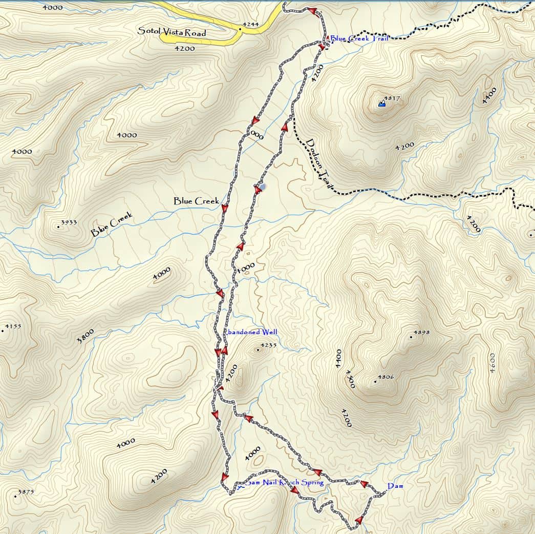
The wind picked up about 03:00 and I awoke to a blustery day. It was cloudy with a chance of rain and the forecast of temperatures falling to the 40’s in the mountains today. This looked like the perfect opportunity to plan a low elevation bushwhack south of Blue Creek Ranch. I would search for Sam Nail Ranch Spring and a dam nearby. After reviewing my maps, this one looked like it was going to be a bit tougher than the past couple of days. I welcomed the change in the temperatures.
The Hike
Packed up, coffee’d up, Ibruprofen’d up, I headed to the parking area at Homer Wilson Blue Creek Ranch. There were a lot of people caching water and also some starting the OML. I passed a whole bunch of hikers until I got down the hill near the beginning of the Dodson trail, however as soon as I struck out down Blue Creek, I was alone. I followed the gravel Blue Creek wash southwest for about 0.9 miles and then turned South across some rolling terrain that was pretty brushy with many small washes. Lots of up and down!
After getting a good look at what was ahead of me, I had to decide whether to pass East or West of Pt. 4235. I’m not sure which would be easiest, but I chose the western side. It is to the right of the peak in the below photo.

An Old Well
I headed through the wash riddled area towards the low pass in the above photo. A I was crossing a wash, I came across an abandoned open well.


This thing is really creepy. It’s about 6′ across and about 20+ feet deep. I had the willies about falling in and NEVER being found again. I carefully crept up to the edge and held my camera out to see if I could get a picture of the bottom to see how deep it was.

The well had the remains of a windlass with a crank handle. It appeared to be dug in some pretty hard fractured rock. This rock was a streak that crossed the wash with a small pouroff below it. Did I say CREEPY??


I was happy to get away from that death trap after marking a GPS waypoint for future reference, .
Finding the Spring?
Looking back from whence I had come, Carousel Mountain receded in the foggy air and an occasional light mist.

Pichaco Mountain was visible through the fog to the east

Heading up to the low pass, I passed a line of old fence posts.They crossed all the way over the hill and to the site of the spring. This photo was taken on just above where the spring should have been. There is some vegetation that indicates that there is some moisture here. But nothing visible and I suspect this is a very hit or miss spring that only flows during the wet season. You can see another fence post in the center of this picture.

Looking back toward Carousel Mountain from the spring site.

An Old Dam
The next goal of this hike was to seek out a dam about 0.6 miles east of the spring. I had seen this dam clearly on Google Earth and it was time to find it. It was really brushy on the way and I did a circuitous route to get there, however I finally found it in a hard rock section of a gravel wash.

The dam is collapsed and silted up with gravel. It has some galvanized piping and a valve, but I suspect it hasn’t held water for a long time. The dam is double cemented walls filled with rubble.

After a rest I took a different line back towards the spring and my return to my truck. It took me higher up the west side of Pt 4235′ and Carousel Mountain came into view again in the mist

Man….it looks like a long, scratchy way back eh? It was!

Passed this little alcove on the way back. Nobody was sleeping in there!

There is a “water feature” on the topo at N29.20631? W103.37087?. Therefore I planned my route back to pass by it for investigation. It appears to be an earthen/gravel levee across a small wash. Built by Homer Wilson? There was no water in the depression. But it’s about 10′ deep and choked with heavy brush. I circled around it as I made a track towards the western edge of the Dodson Trail.

Hiking Big Bend National park can be pretty rough going. However I finally hit the Dodson and followed it around for about 0.3 miles to the ranch house.

Back to the Chisos Basin
I was out for about 6 hours and pretty beat up after this hike. So I headed back to Basin to nurse my wounds. My daughter was coming tomorrow and I wasn’t going to hike in the morning as I expected her before noon.
Although this hike wasn’t real long it was a bushwhack the whole way. I logged 7.6 tough miles with a total elevation change of ~ 2,500′
Don’t know all what’s planned for tomorrow, however I know for sure there is a Boquillas overlook hike and a South Rim Loop day hike in the cards for Hiking Big Bend National Park.
Day 5 Hiking
Day 5 was a pretty quiet day and quite cold. The Basin was in the 40’s. My daughter arrived about 14:00 and was ready to grab a little something to eat and was anxious to make a short hike. We chose Grapevine Hills. There were so many people there that I didn’t take many pictures. The hike was a short 2.4 miles with a 700′ total elevation change. We headed back to camp in the early evening and spent a cold 39 F night in the Basin.


Day 6 Hiking
Day 6 Hiking Big Bend National Park started cold and crisp at about 40 deg F, but it looked like we would have some sun. We decided to do the Boquillas Overlook and had a newbie with us. After the drive to the Marufo Vega trailhead, we squeezed in among about 15 other vehicles.
The Hike
Shouldering our packs, we hit the trail with 60 deg F temperatures and light winds. We quickly breezed up the wash and started the climb to the top of the mesa. If you haven’t hiked the Marufo Vega Trail before, there is a desperately steep section just after the first saddle on the trail. It is rocky and narrow. I think it’s harder coming down than going up, but either way it does present a challenge.
We made our way to the point on the trail where we would exit cross country to the east. By this time the temperatures had climbed into the 80’s with no shade or wind. We continued across the wash, around the pour off and up the draw that leads to the overlook. By the time we reached the overlook, our newbie had knocked down 3 liters of water. I had to give him a liter of mine for the way back. It was pretty hot and he wasn’t used to the dry air.
We stayed about 45 minutes at the overlook, had lunch and took a few pictures in the clear air. The river had a nice color to it and we watched the vultures, ravens and swifts soar and wheel above the canyon.


On the way back we found an area that was covered with hundreds of resurrection plants (Selaginella lepidophylla). Sorry no photo.
As always, the view at the overlook is one of the best in the park. Certainly in the top 10, and one of my favorites.
Miles logged 7.6 with a total elevation change ~ 3,000′
Day 7 Hiking
My troops were pooped after the trip to the overlook on day 6. So we decided to do a driving tour down the RMSD. We stopped along the way at the “highlights”. Just like the rest of the carbound bunch! We wanted the newbie to get a chance to see the bigger picture.
A Driving Day
We checked out Tuff Canyon, Castolon Store and Santa Elena Canyon. There were so many people at Santa Elena, therefore we didn’t even walk across Terlingua Creek. We then drove the Old Maverick Road washboard, stopped at Luna’s Jacal, and drove into Terlingua to check out the cemetery and the store.


Only took these few photos and we headed back to the Basin to grill venison cheeseburgers and mac and cheese.
Day 8 Hiking
The troops were sufficiently rested to do a South Rim Loop today.
The Hike
We hit the Laguna Meadow Trail under clear skies, cool temperatures ( 50 ish) and light wind. The trail wasn’t too crowded. However by the time we reached the Rim we had seen more than 50 hikers. The weather turned very overcast and gray. The Sierra Quemada range below the Rim was very dry. Boot Spring is dry. The pools in the canyon above the spring are hard to reach and the water is kind of green. The mountains are desperately in need of a spring rain. However Boot Canyon is still a magical place. We spent almost as much time there as we did on the Rim.


Miles logged – 13.3 Total elevation change ~ 5,500 ft
Dinner in Terlingua
Once we returned to the Basin, we grabbed a fresh change of clothes and headed to Study Butte for a shower and a meal at the Starlight Theater in Terlingua. The wait for a table at the Starlight was 2 hours. We hung out in the outdoor cantina and watched the sunset light up the Chisos. The Starlight still has plenty of draft Big Bend Brewing Co Beer. The store has 4 or 5 kinds in cans.


We stopped on the way back at the Grapevine Hills road and got out and star watched for a bit.
It was a long day so everyone was out in a flash. We got up the next morning, tore down the camp and hit the road by 08:30. We took I-10 because my daughter was going back to College Station. During the drive, we saw a bunch of Pronghorn and Bison north of Marathon.
Postscript:
Do I like going to BIBE at Spring Break? No.
Would I do it again? You betcha, if that was how it had to be.
Off trail hikes make Spring break crowds invisible during the day, however, If you can put up with the other inconveniences that the crowds bring, it’s not too bad.
Total Miles logged – 46.3 and didn’t even add up the total elevation change, but it was in the 16,000′ range
It was a great trip and the good news is I think I may be getting back there around April 1st
Finally if you got this far, Thanks for reading.
Thank you for the photos. I am the Patty of Patty spring and have great memories of Big Bend. I worked there in the 80s and think
a return is long overdue.
Oh cool. Hello Patty. Nice area for exploring. Thanks for the info!
Geez, you sure seem to be able to navigate the area very well, and with confidence. Enjoyed reading your narrative and your pictures. Well done on all your hikes. Seems as if you prefer the path less traveled.
Thanks for reading! “All those who wander are not lost”
Steve, thanks for the story and photos! Have you ever been to Red Ass Spring northwest of the Chimneys?
I have. Interesting place.
Great sight and pics, as well as write ups. Googling Terlingua (missing home) and found your site.
salvageyardranch.blogspot.com
Glad you checked it out. I looked at your blog too. Looks like a heck of a project!
I love your photos and your story telling! Like I said on Big Bend Chat, you are an inspiration. I shared this with my wife and told her, “I want to be like Badknees”! I was out there April 12 through 18 participating in a photography workshop offered through Precision Camera in Austin. Leaned a lot and will continue to get better on the photography side. I really like the way you hike off trail. Another hiking buddy recently told me that a few of the other guys we hike with had said we had seen all there was to see at Big Bend. I know its not possible to see all there is to see and this trip report, alone, makes that point perfectly clear. Thank you very much for sharing your “gifts”.
Thanks for the kind words. I can assure you that it takes a lifetime to see all of Big Bend. Good luck on your photography efforts…remember it’s all about the light!
Enjoyed the photos and commentary very much.
The story provides a lot of insight to many of the unknown treasures of Big Bend!
Very glad that Richard did not fall into the old abandoned well!
We would still be looking for him.
Thanks for the comments Steve!